
MICKLEBY is a village near Whitby. We were there by default, having set out with two routes ready, one a seaside stroll should the coast be pleasant, the other, just inland, should the weather be horrid. I was looking on the Ordnance Survey map for the backup route and the thing that caught my eye was the symmetry of this simple little circuit.
At the north end runs Mickleby, a single 500-yard street. A little more than a mile away, to the south, is the village of Ugthorpe which is also a single 500-yard street, but more churched. Each village has a pub, and each stands at the same altitude of 600 feet and indeed each has its highest point marked with the figure of 177 metres on the OS map. We’d started at Ugthorpe before, so now it was to be the other.
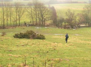
An escaped cow wandered the street without much adventure. We sat in the car, outside the White Hart, watching the rain and the cow. The sky was uniform grey in all directions and it was not going to empty for our pleasure, so we donned all the waterproofs, head to foot, and splashed off across the pastures. And soon we could see Ugthorpe across a valley that is a pleasant shape of hedged pastures, wooded by the waters.
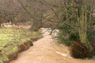
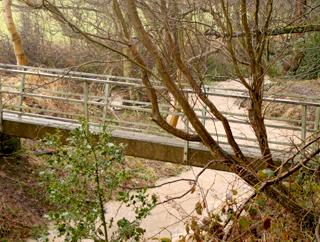
Of streams, the main is Mickleby Beck: well bridged in steel and running a torrent, it joins the sea at Sandsend. A tiny stream was noisy and vigorous.
A good mile done we reached Primrose House, a farm which is not as pretty as its name, and we had reached Ugthorpe. There is the Black Bull here but we did not dare, would have contaminated the place, so after a bite of sandwich under an outdoor crucifix we hurried on. My coat was leaking, but my navigator said “it’ll be summer soon, you’ll last till then”.
Ditches along fields threatened to flood rabbit holes, water was gushing in places it shouldn’t be and halfway across the valley I had a pessimistic thought: what if the bridge is down? So when we got there and couldn’t see it and dithered a bit, spirits sank. That was only for five minutes, for we found our crossing safe and sound, and could admire the valley prettiest in its curves here.
A climb and we were done and drenched, back in Mickleby where I asked a woman dog walker if there were sea views from the route we’d done; but no, “just fields”. On our drive home we noticed a policeman standing by a bridge, this was the day a woman and her Landrover were washed down river.
Fact file
Distance: Three miles.
General location: North York Moors.
Start: Mickleby.
Right of way: Public.
Dogs: Legal.
Date walked: February, 2010.
Road route: Mickleby signed from the A171 Middlesbrough to Whitby road.
Car parking: Roadside in Mickleby.
Lavatories: None.
Refreshments: The White Hart at Mickleby and the Black Bull at Ugthorpe.
Tourist and public transport Information: Whitby TIC 01723 383636.
Map: Drawn from OS Explorer OL27 North York Moors eastern.
Terrain: Small valley.
Difficulty: Quite easy.
Please observe the Country Code and park sensibly. While every effort is made to provide accurate information, walkers set out at their own risk.
Directions
When in doubt look at the map. Check your position at each point.
Keep straight on unless otherwise directed.
1. From White Hart inn, road east and right for 100 yards, drive (fingerpost) on right, stile by house, across field, stile, downhill, step-stream, 11 o’clock, stile and footbridge, stile and left, stile and down into wood and path curves right.
2. Metal footbridge over Mickleby Beck with stile, 2 o’clock across corner then left uphill by hedge and stream to your right.
3. Stile (waymark), angle 300 yards at 11 o’clock to a corner and join hedge to your right towards farmyard.
4. Stile to right of fieldgates at farmyard, 25 yards, gap by stile, path by conifers past farm, stile, 1 o’clock across field, gate (waymark), by hedge to right, gate (waymark), path.
5. Right to road into Ugthorpe, some pavement. Fieldgate (sign) on right opposite Black Bull, hedge to right, fieldgate (waymark), fieldgate.
6. Stile by fieldgates, ten yards on track, fieldgate (waymark) on left and immediately right downhill, gate (waymark), stile (waymark) 50 yards.
7. Left before trees and gently downhill over field, 300 yards, right and downhill over grass to Mickleby Beck.
8. Footbridge with stiles, 11 o’clock for 200 yards steep uphill to corner then by hedge/fence to right, fieldgate, fieldgate and bridge, track, stile by gateway, track 100 yards then over grass towards farm.
9. At farm (fingerpost), right 50 yards, left to stile by barns, stile, stile/fieldgate and right to road and pavement.


Comments: Our rules
We want our comments to be a lively and valuable part of our community - a place where readers can debate and engage with the most important local issues. The ability to comment on our stories is a privilege, not a right, however, and that privilege may be withdrawn if it is abused or misused.
Please report any comments that break our rules.
Read the rules hereComments are closed on this article