
PICKERING is a super market town, with a bit of a buzz. We left eastwards, taking a quiet road through a spread of post-war estates, half a mile to East Villa 1884, after which there were a few more houses and from one rang a “good morning”. Then we were tracking on with chaffinch, tit and sparrow in the hedges and a fox on the pastures.
The route turns towards the north, and from now on and until the last mile it follows the southern boundary of the North York Moors National Park. I can’t be as exact regarding which lengths run through the Queen’s Duchy of Lancaster Estate, because I can’t find a map of that.
The first park’s boundary mile took us up and through Howl Dale, a typical straight and narrow wooded valley. We saw two deer twice, first a hint of them still and careful a hundred yards up the edge and then a few minutes later they bounded across the track.
From the howl there’s a turn across spacious flat farmland, across the Whitby road, with Walkers Welcome’ signs and views from High Scalla Moor. Then we slipped into the next valley, a more serious affair.
For here an ace steep path took us down and down through the woods, and at the bottom runs Pickering Beck and it swirled between its sandbanks. This is the water that floods Pickering. Debris from the last spate was snagged six foot higher on the footbridge. Not that one needs said bridge except to reach and cross the railway line a stone’s throw away.
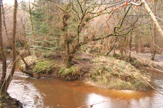
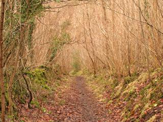
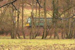
We waited, but heard no steam train coming and moved on a different way, through more woods, a winter scent of mixed conifer and broadleaf and on path surfaces that, throughout the route, if sometimes muddy, did not stick and slow. The river ran silent beside, in powerful, bank-chewing curves; a tree grips an island, a crow gave a rough call and 100 pigeons left the tree tops.
We caught a bit of sun over tall Norway spruce that had cast very long leathery cones. And here there is an open access field, eco land along the river. A train came by, headed our way to Pickering, but not a steam train. We noticed a Duchy notice about dogs and reached a junction with river, road and rail.
A path runs just above these and depending on your tastes you can either admire the sidings of rail carriages or the dramatic overgrown quarries, a series of chambers of rock with the layers of sandstone and limestone clear, and information boards that remind that once we had a climate like the Bahamas.
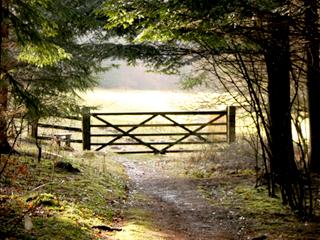
And for a finale there’s the castle visible and towering, if you feel the need. We took the town’s fine main street, walking shop and all.
Fact file
Distance: Six-and-a-half miles.
General location: North York Moors.
Start: Pickering.
Right of way: Public and open access.
Dogs: Legal.
Date walked: February.
Road route: From York, A64 to Malton then A169.
Car parking: Eastgate car park, pay and display.
Lavatories: Car park.
Refreshments: Inns and cafes.
Tourist and public transport information: Pickering TIC 01751 473791.
Map: Drawn from OS Explorer OL27 North York Moors eastern.
Terrain: Valleys, mostly.
Difficulty: Moderate.
Please observe the Country Code and park sensibly. While every effort is made to provide accurate information, walkers set out at their own risk.
Directions
When in doubt look at the map. Check your position at each point.
Keep straight on unless otherwise directed.
1. From roundabout uphill on Whitby Road pavement. Right to Ruffa Lane pavement. At last house, road becomes track.
2. At farm, stile by fieldgate and right by fence 50 yards to path between fence and hedge.
3. Left to path into wood, 150 yards, ignore left fork. After half a mile, at junction straight on to level track.
4. At wood edge, left to path (waymark post) uphill 20 yards, stile (info board) into field, up by fence, stile (waymark) to fieldedge path, stile (waymark) to path in edge of wood. Stile out.
5. Cross main road. Fieldedge path (no signs).
6. Stile to woodland path, 100 yards, right at junction (waymark post) to path downhill, 100 yards, cross path and carry straight on downhill on steepish path by wall.
7. At bottom, small two plank bridge, 100 yards, left to path immediately before footbridge over Pickering Beck (waymark post). Plank footbridge, fieldgate (sign).
8. Stile by fieldgate into long open access field, so either: riverside to snickelgate at end of field or 300 yards, snickelgate (waymark) into wood and immediately right to wood-edge path 9. Pass end of open access field at snickelgate to your right. Ignore left forks. Stile to drive then road.
10. At road junction, path on left (fingerpost) up into wood and right-hand of two paths, the one with steps. Contour below quarries.
11. Path ends, cross road to pavement, quarter mile, left to main street, uphill then downhill, left to pavement by A170, roundabout and car park.


Comments: Our rules
We want our comments to be a lively and valuable part of our community - a place where readers can debate and engage with the most important local issues. The ability to comment on our stories is a privilege, not a right, however, and that privilege may be withdrawn if it is abused or misused.
Please report any comments that break our rules.
Read the rules here