
IF you enjoy riding your bike without constantly having to check the route and consult the map; then this may be one for you.
Most of this month’s route is within the confines of the valley of Bransdale, just north of the A170 between Helmsley and Kirkbymoorside.
There’s only the one road, which runs up the valley on one side, turns across the head of the valley, and then back down the other side.
All you need to do beforehand is decide if you want to follow a clockwise direction, or an anti-clockwise direction.
I have to admit that I’m not very good at carrying drinks on my bike. I usually try to search out a pub or café instead. Let’s make an exception for Bransdale, where facilities are lacking. There’s no running water and farms are supplied by their own springs, so carry fluids with you.
Also a quick heads-up on the topography. This month, things get a bit lumpy. If climbing hills isn’t your thing, I’d say don’t worry. Just pick a fine day and when the hills do come, just hop off and enjoy the walk. You’ll appreciate the scenery more.
Start in Kirkbymoorside from the Town Farm car park, off the western side of the Market Place. Approaching from the A170, watch out for the Kings Head Hotel on the left of the Market Place, and immediately past the building, turn in to a narrow entrance, between stone gate posts. It gives the impression that you may be entering the hotel’s own car park, but this is in fact the public long stay. It’s a one-way system too; so walk your bike back out to the front of the hotel.
Kirkbymoorside was bustling when I visited on a Thursday morning in the middle of June. It was mid morning, but I’d had no breakfast so tried the Penny Bank Café in the Market Place. It still looks like the Yorkshire Penny Bank it once was. I had excellent fresh scrambled eggs on granary toast for £4.50. Proper strong coffee too.
Start the ride with the car park entrance behind you, go to the left, and head roughly North West up the Market Place, away from the A170. Where the road splits, keep left on Kirby Lane. Follow Kirby Lane out of town, climbing gently towards the village of Fadmoor. After another mile, take a left, signed Fadmoor. Now if you’ve had a late morning start, and it’s been some time since breakfast, I think that it is perfectly reasonable to stop off early in the ride for a spot of lunch. Sadly, The Plough at Fadmoor has been shut for a few years.
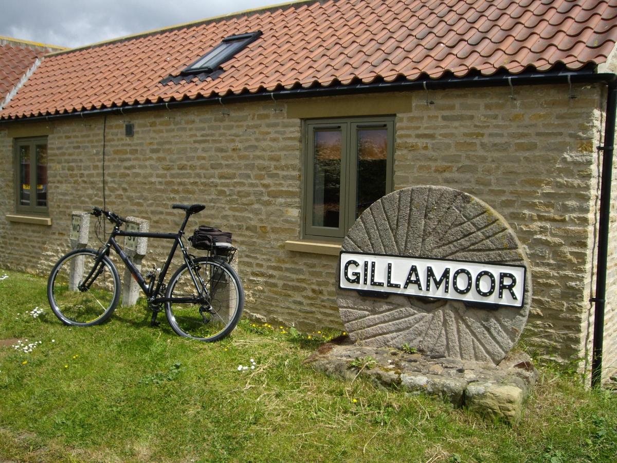
Fortunately, it’s but a short detour to the Royal Oak, at Gillamoor. In which case, take the junction on the right, opposite the old Plough and across the village green, through the main part of the village (heading east). Otherwise, if skipping the pub stop, just keep straight ahead (roughly north) and avoiding the larger part of Fadmoor village.
For those who’ve availed themselves of the pub stop, turn back left out of the pub, retrace a few yards back to the edge of Gillamoor village, and then take the right turn, heading roughly north west. This is a steady climb on a nice single track road with gravel down the middle. You’ll re-join the main route at a junction in about three-quarters of a mile. If you’ve skipped the pub stop and carried on straight ahead in Fadmoor, then the road from Gillamoor will join your route shortly from the right.
Continue forward now, heading approx north and initially downhill on a 14 per cent gradient. Climb the other side and over a cattle grid, then the road takes a distinct turn to the left. Our route stays on the road; but do pause for a moment to view the bridleway which leaves the road here and continues more directly up (north) towards the higher part of the moor.
This old drove road is Rudland Rigg, running for six miles to Bloworth Crossing, on the route of the Lyke Wake Walk. The first time I rode up this bridleway would have been with the Teesside Cyclists’ Touring Club (CTC) hardriders’ section, in the early 1970s. That was before mountain bikes had been invented. We’ll stay on the Tarmac today. Pass Rudland House to the left and Rudland Farm to the right, with the road being fairly level for a while. I’m mentioning the names of these buildings in case you are following the route on an OS map, where they are indeed named. On the ground, the reality is different and very few farms hereabouts have any obvious name signs at their gate. Off to the right, but higher up the hillside, you may notice unevenness in the terrain. These pits and small spoil heaps are all that remains of opencast coal mining activities in the 18th and early 19th century.
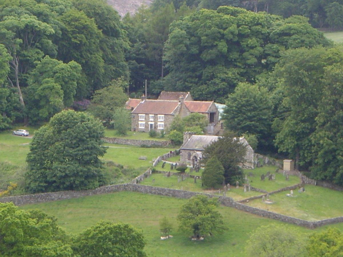
A descent follows to the distinctive Ousegill Bridge with its double arches, then a hairpin turn to the left. A short climb, gaining about 30 metres in height, then a sharp turn right again and the road resumes its general northerly route as before. A very straight gentle climb for nearly a mile and the road plateaus out, before descending again across a cattle grid, to Spout House Farm. Keep right here, as the road does it’s best to follow the contours. We are nearly at the head of the valley. Look over the wall to Continued: Page 59 the left and you may spot a stone sun dial in the field just before Toad Hole farm which is exceptional in having a prominent name sign at its entrance. The owners must like the name. Passing Toad Hole and climbing again you’ll get the first sight of Bransdale Lodge and St Nicholas Church at Cockayne, over to the left. Take care at the warning sign for the 20 per cent descent that follows. The road curves left and loses about 40 metres in height, to cross a stream at the hamlet of Cockayne. Watch out for the rough road surface at the bottom. I’d encourage you to take a short diversion which will mean a walk up the lane signed (to the church) on the right. I’ve read somewhere that the name Cockayne was a mythical medieval location. An English version of Utopia perhaps? Anyway, there are some nice seats at St Nicholas Church for you to enjoy the peace and tranquillity. Inside the church is an unusual vaulted wooden ceiling, which gives the impression of being inside a very large barrel. Retrace back to the road sign, and take the right towards Helmsley. Cross the cattle grid, and this area of land below Bransdale Lodge feels very much to me that it may once have been a deer park. Three members of Clifton (York) Cycling Club give a cheery wave as they pass in the opposite direction, before the next cattle grid and a very nice stone bridge mark the end of my theoretical deer park. Dismount to negotiate a gate across the road.
Did I mention climbs? Here we start the first of the two major climbs we’ll encounter before returning to civilisation. From 230 metres at the cattle grid, to 360 metres or thereabouts at the top of the escarpment. Unfortunately, the top is nearly a mile and a half away. My 40 year old Jack Taylor bike is confined to the shed at the moment, with a loose steering bearing that I’m loathe to investigate; in case it may be something terminal. Meaning that I’m making use of my relatively sprightly 12 year old Cannondale Bad Boy hybrid, and the accompanying low mountain bike type gearing. Hurrah! Feel free to have gentle stroll up though. In Bransdale there’s not much chance of an audience, so no loss of face.
At the top (where a bridleway joins from the rear right) look across to the right to spot a distinctive boundary stone. The side facing you is marked with a prominent “K” indicating Kirkbymoorside. Impress any companions by telling them that the reverse side, out of sight, bears an “H” for Helmsley. You are then rewarded with a long, long downhill. This is Lund Ridge. Woodland appears on the hill to the right and then you pass through the tail end of this wood. There’s a phone box and small church (St Mary Magdalene, built 1882) off the road on the left. Regular readers will know that architecture forms part of my varied interests. If you are similarly inclined, you may be surprised to learn that the renowned critic Nikolaus Pevsner commented favourably on the young architect responsible for this church on the moor, the appropriately named Mr.Temple Moore. You couldn’t make it up! Leave your bike by the phone box and a footpath just beyond allows access to view the church.
The road continues to descend for another 100 yards beyond the church and crosses a stream before you start the final climb of the day. This is Cowhouse Bank, named after the farm at its foot, on the right. I wasn’t in a rush, so enjoyed a gentle stroll to the top. My 20 year old Ordnance Survey map suggests views off to the left, but this is much obscured by tree growth. A few gaps in the trees half way up let you look onto Beadlam Rigg, behind which hides our eventual finish at Kirkbymoorside. Where you see the road start to curve right, this indicates the top. The good news is that its downhill all the way now into Ryedale. The distant hills are the Wolds, and we won’t be going that far today.
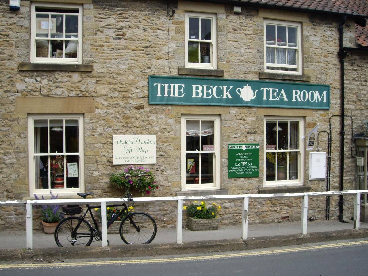
A long straight descent follows, down through the small village of Carlton, to meet the main A170 at a T-junction on the outskirts of Helmsley. I’m feeling thirsty, so turn right to detour into town. Helmsley is always busy. Even on this mid-week afternoon, the market place was thronged with day trippers. It’s especially popular with bikers of the motorised sort. So we’ll seek out a tea place off the busy centre. Straight over the mini-roundabout and left at T-junction, onto Castlegate (actually marked on the wall facing you as being Church Street). Here on the left you’ll find The Beck Tearoom who did a nice pot of tea, with extra hot water, all for £1.95.
Retrace back on to the A170 out of town (direction Scarborough), and near the garage on the right look out for the start of a shared path (pedestrians and cyclists) on the left. This takes you safely for the next couple of hundred yards, to a junction on the right, marked Harome 2. Cross here and take the road for Harome, noting the bridge parapets which mark what was the old railway from Helmsley to Scarborough. We’ll see part of this line again later.
At Harome, pass the thatched Star Inn, on the right, and then follow the sign left for Wombleton. Note the various thatched cottages; quite unusual for North Yorkshire. Continue in the direction of Wombleton. Watch for the sign for the caravan site. At the entrance, there’s a memorial to No.6 (Royal Canadian Air Force) Group, Bomber Command, who flew from RAF Wombleton, 1943-1945.
Continue into Wombleton, where take the second right at The Plough (open lunchtimes except Mondays, and serving Theakstons ales), direction Welburn. Reaching Welburn, its left at the T-junction and straight over (with care) the A170, signed Kirkdale. Every travel writer will tell you about Kirkdale, so I’ll fly in the face of convention and give it a miss. I’ll throw in some railway stuff instead. So across another disused railway bridge, (the old line from Helmsley) then right at the T-junction, still signed as Kirkdale. Take care on the narrow bendy descent to a ford (dry in the summer), but try to glance right where you’ll just catch sight of a nice railway viaduct across the valley of Hodge Beck, which actually flows down from Bransdale Moor, where we were on the furthest extremity of the ride.
A short climb from the ford brings you to a crossroads. We are going straight over to Kirkbymoorside. Some gremlins had been at play with the sign at the time of my visit, so just go straight ahead, whatever the sign might say.
However, I did take a short detour to the right to view the first house, which is in sight from the crossroads. This has a railway-style sign high up which reads Starfitt Lane. It’s in line with the eastern end of the old viaduct, and I’ll venture my second guess of the day and say it looks to me to be the (once) crossing keeper’s cottage. I’ve not been able to find any reference to it though. Does anyone in Kirkbymoorside know?
Continue from the crossroads towards Kirkbymoorside. Just before reaching the main A170, there’s a broken Tarmac path to the left. So join this for a while to avoid the traffic. At the 40mph sign, keep left to join the old road passing the school on your left. Look for Tinsley Garth on the left, and take this (one way system) to bring you to Town Farm Close on the left, and being the back exit from the car park.
The Maps: Ordnance Survey Landranger. Number 100 Malton & Pickering, (or OS Explorer map OL26, North York Moors – Western Area)
The Pub: The Royal Oak, Gillamoor, YORK YO62 7HX. Tel. 01751 431414
The Cafe(s): Penny Bank Cafe, 19 Market Place, Kirkbymoorside, pennybankcafe.co.uk; The Beck Tearoom, 3 Castlegate, Helmsley, becktearoom.co.uk
The Bike: 2003 Cannondale Bad Boy. Running on 1.5” slicks.
Distance: I did 33 miles (including various detours) otherwise, approximately 28 miles without stops.
Car Park: Kirkbymoorside, Town Farm Car Park, YO62 6AU, Long stay, £4.30 for six hours


Comments: Our rules
We want our comments to be a lively and valuable part of our community - a place where readers can debate and engage with the most important local issues. The ability to comment on our stories is a privilege, not a right, however, and that privilege may be withdrawn if it is abused or misused.
Please report any comments that break our rules.
Read the rules hereComments are closed on this article