
GEORGE WILKINSON heads to the coast for a day out at Runswick Bay.
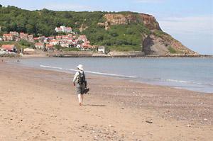
Runswick Bay curved wide and far, beautiful in blue and yellow and held by cliffs. We walked the sands, eyes inland to the thick scrub that covers the boulder clay that falls to the beach, looking for our route. We found it, inconspicuous and unmarked, by one of the chalets that decorate the seashore.
It’s a slightly rough path, this is unstable ground. But then out in the open, above the scrub line, a pleasant track took us further up to cross the disused railway line for a back lane that did the job nicely, taking us a mile inland.
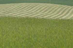
This lane is a dead-end and just for a farm or two, between the grain fields and the cut fodder grass, and there wasn’t a single Land Rover.
By now we’d gained some height and topped out and turned round at the coast road where a sign bore the litany of seaside names, Staithes, Sandsend, Whitby… all near.
And at the top is the Mickleby Landfill Site, landscaped smooth and sprouting stubby pipes for the methane gas. The air was fine, but we didn’t get any ozone as a brisk westerly blew away any breeze off the sea a mile away.
A hare ran down a dusty track through gorse, bumblebees ground hugged for the clover, a farmstead is made of sandstone and tin sheet.
We crossed the railway line again, at a cutting this time, and them came an off zone where an old barn looked bleached rickety under its lichen yellow asbestos roof, where the footpath field margins were poor and there’s a big pheasant pen.
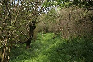
But that was just ten minutes, and then the descent, an energising mix of steep dives into charming woods of holly, hazel, birch, and especially oak, and through the branches were glimpses of the white cascade of Runswick Bay houses.
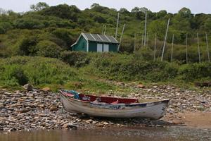
A boat, the Jennifer Margaret from Whitby, fished the bay. On the beach, two jackdaws bathed, visitors strolled, skimmed stones and children favoured dams rather than sandcastles. We paddled and got the sand between our toes, and there were acres of sand because we’d checked the tide times.
Assuming you did the latter and aren’t trapped waiting for the retreat of the breakers or scrambling through scrub, then the walk takes you past, in sequence, ice cream, the jetty, the loos, the lifeboathouse, on to the Cockpit and to the Royal Oak.
And then, if you parked at the top, there are steps for a nice way up through the houses to a twisty, old, one-time road.
Directions
When in doubt look at the map. Check your position at each point. Keep straight on unless otherwise directed.
View a map of the Runswick Bay country walk>>
1. From the bank top car park entrance near the Cliffemount Hotel, left to road, left down steep road with steps to side.
2. On to beach and right, 500 yards.
3. Right to small metal gate (no waymark) by one metre cube of concrete and chalet with roped steps. Path up through woods/scrub. Ten yards after a tree fallen across path take steeper left fork, path sometimes boggy, ignore paths to right, becomes sunken.
4. At top of scrub line left 100 yards over grass to fieldgate (waymark) to good track uphill. Fieldgate (waymark), ten yards, fieldgate (waymark other side), track uphill (waymark).
5. At junction with disused railway line by house, cross to track (waymark), becomes road.
6. Left at main road, verge, 100 yards, path up bank (sign) to hedge gap, left to corner then right following hedge, downhill.
7. Switch to other side of hedge (waymark post), fence to left, straight on from disused tip corner (waymark post). Downhill on grassy path on rigg above two converging streams, while on this follow path sharp right, over grass to hedge, 20 yards, through hedge so stream bed to left and fence/field to right.
8. Footbridge, swing right and up to stile, uphill near fence to your right then aim to right of farm.
9. Fieldgate into yard (waymark), 50 yards, left under lean to barn (waymark under roof), right at next barn, 100 yards, wooden fieldgate to track (waymark on barn to right), 50 yards, fieldgate on left (waymark), track downhill, fieldgate (waymark).
10. Fieldgate and over railway bridge, stile/fieldgate between chalet and old barn (waymark) downhill by old fence, boundary becomes hedge and wood with poor footpath surface. Left at field corner marked by grassy boundary (waymark post), 50 yards, right, downhill along field-edge – path not reinstated. Stile on left in corner (waymark), path steep downhill and swings right through woods.
Negotiate buildings to beach.
11. Left along sands. Up steps between café and jetty, right, pass Public Conveniences and winch, steps uphill, steps to right of pub, pass Seagull Cottage. Steps swing left after The Old Cottage, right at junction with old path/road and uphill. Left at top of bank.
Fact file
Distance: Four miles.
General location: Coast near Whitby.
Start: Runswick Bay.
Right of way: Public.
Dogs: Legal.
Date walked: May 2011.
Road route: Via A174.
Car parking: At bank top, pay-and-display car park and some roadside, at bank bottom, pay-and-display only.
Lavatories: Bank top car park and near beach.
Refreshments: The Cliffemount, Runswick Bay and Royal hotels and café.
Tourist and public transport information: Whitby TIC 01723 383636.
Map: Drawn from OS Explorer OL27 North York Moors eastern area.
Terrain: Coastal hinterland.
Difficulty: A bit rough in places.
Please observe the Country Code and park sensibly. While every effort is made to provide accurate information, walkers set out at their own risk.


Comments: Our rules
We want our comments to be a lively and valuable part of our community - a place where readers can debate and engage with the most important local issues. The ability to comment on our stories is a privilege, not a right, however, and that privilege may be withdrawn if it is abused or misused.
Please report any comments that break our rules.
Read the rules hereComments are closed on this article