
A FEW miles west of Scarborough lies the village of East Ayton, not much to see on the surface as you drive through on the busy A170, so let us stop for a while and explore the history of this fascinating place.
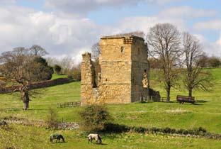
There is an interesting church where much of the architecture is Norman, pride of place being the Norman font which has been in use for more than 700 years. The church was founded by the de Aiton family around about the 12th century, they built and lived in Ayton Castle from 1120 to 1359. After the de Aitons it was the stronghold of the Eures family, one of which. Sir Ralph Eures was the governor of Scarborough Castle during the reign of Henry VIII.
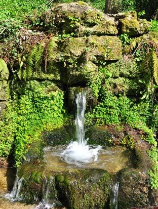
At the boundary of East and West Ayton is a fine old bridge spanning the River Derwent and it is the Derwent which we trace back into the grand gorge of Forge Valley. As we walk towards the valley we see, elevated above the Derwent, the ruin of Ayton Castle. Further along Forge Valley the gorge sides are heavily wooded and it was along here that the monks from Hackness had their forge, this was near to the water spout known as ‘The Old Man’s Mouth’, an obvious name if you study its features.
But let us go further back than the monks, say 160 million years, back in time when Forge Valley was covered by the sea where marine life swam and lived. After millions of years these creatures became fossils which are to be found today in the quarries and stone walls around Forge Valley.
On the walk you will come across Whitestone Quarry and Wallis’s Quarry where evidence of fossils still exist. As you walk through the woods above Forge Valley you will pass by Osborne Lodge, the stone wall surrounding the farm contains fossilised sea shells. Please just look and wonder at them and do not damage the stonework.
In its lifetime Forge Valley has seen industrialisation of the surrounding area. A railway line was proposed to run from Scarborough to Pickering via Forge Valley to meet the Whitby line at Scalby.
However, when it came to the planning stage it was found to run through Lord Londesborough lands and after objections from his Lordship the railway line was not built.
Your route

On the horizon you will see television and other masts in front of you, so keep on climbing and enjoy more grand views across the Howes and Seamer Beacon on your right and eventually you reach Row Brow Wood and the masts. Turn left here to take the path on the edge of the field, through the trees on your right you have grand views across to the coast and Scarborough Castle.
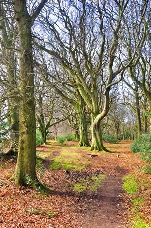
Across the field keep straight ahead into the wood, do not take any other path, keep to the one on the tree line edge of the field. As you walk through the wood the trees vary in size and stature, changing to a pine forest then back to deciduous woodland. Soon the path opens out a little through some huge old trees, their large branches sweeping close to the ground are obviously enjoyed by children.
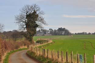
The view on the right, if you can see through the trees becomes grander and grander as your eyes wander along the valley to Hackness and Troutsdale, Switzerland in miniature. Soon you see a row of trees and earthworks in the field on your left, these are scamridge dykes, probably built to keep cattle from wandering or to keep invaders out of some ancient settlement. The path soon narrows and undulates, still keep high and walk along the wall line keeping straight ahead at all times. The large house on your left is Osborne Lodge with some old walls from a previous era incorporated. Soon the path starts to descend to make its way down through the wood to the road. Keep straight ahead on the most obvious path at all times then follow the path to the right as it eventually sweeps down to exit the forest into Forge Valley.
Cross the road and turn left on the narrow roadside footpath along the side of the River Derwent. Climb the hill then take the next left turn then right to make your way back the your transport.
Facts of the Forge Valley country walk
Distance: 6½ miles (11km)
Time: Two hours
Grading: Easy
Start/Grid Ref: East Ayton, grid ref. 992850
Best map: OS Outdoor Leisure 27
Parking: Street parking along Moor Lane near the church
Refreshments: Pub and fish and chip shop on the main street
Public toilets: None


Comments: Our rules
We want our comments to be a lively and valuable part of our community - a place where readers can debate and engage with the most important local issues. The ability to comment on our stories is a privilege, not a right, however, and that privilege may be withdrawn if it is abused or misused.
Please report any comments that break our rules.
Read the rules here