
FROM a narrow gorge between Farndale Moor and Westerdale Moor rise several springs which join together then tumble their way down beneath the rocky outcrop of Esklets Crag towards Westerdale village.
This water is the beginning of a mighty river. As insignificant tributaries bounce and burble their way along they join together to collecting more moorland water from gills and becks to form the River Esk.
The Esk increases in volume as it rushes on its way brushing Westerdale to continue beyond along the Esk Valley on its way to the sea.
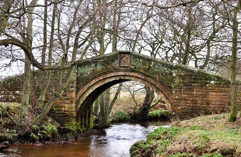
There are many bridges along its path but there is one in particular that interests me, Hunters Sty Bridge. This ancient stone bridge on the edge of Westerdale village is a bridge to nowhere. It leaves the road from Westerdale to cross the River Esk to exit at a field gate. The road once forded the Esk a few metres away but now has an insignificant modern crossing. Who built the bridge and why?
It is known that the Knights Templar were in the Westerdale area in medieval days and were involved with many religious buildings. They built a position of strength in having a hall and land given to them by Guido de Bovingcourt.
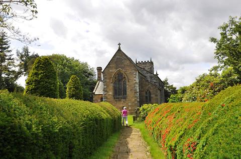
There is also evidence in Westerdale church and churchyard of their style of building and carvings in stone. Although Hunters Sty Bridge was restored in the 19th century by the Duncombe family, the bridge arches are of medieval construction and this could be attributed to the Templar Knights. The Templars were given the Westerdale Preceptory early in the 12th century which lasted for a couple of hundred years until October 13, 1307, when many Templars were arrested in France. They were charged with numerous offences, including heresy, obscene rituals, financial corruption and fraud. They gave forced confessions under torture and many were burned at the stake. The troubles spread on a decree that all Templars should be arrested and their assets seized.
So why was the bridge built?
The surface of the bridge is paved as though it could have been part of a trod linking abbeys and priories which would have been well-used in those times.
But the width of wheeled transport would have probably used a wider path and forded the river at the bottom of the hill. So we had a bridge to somewhere in medieval days but modern life seems to confirm that we do indeed have ‘a bridge to nowhere’.
Your route
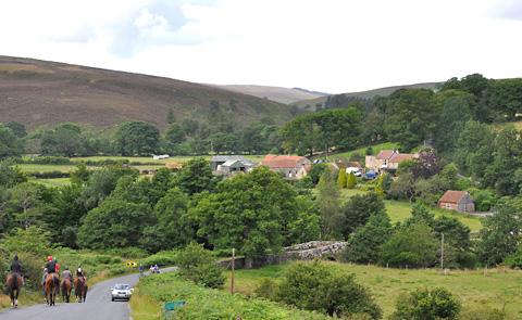
For this month’s walk, I am taking you onto the moorland country roads around Castleton and Westerdale.
Easy walking with a good surface underfoot. Hardly any traffic at this time of year and solitude of grand proportions, just you, the wind and a few sheep.
Starting from the NatWest Bank in Castleton, head off downhill past the public toilets then turn left signed to Guisborough.
Continue downhill then just before the bridge over the River Esk, turn left along the Westerdale road past the cricket field. No footpath for you along here, but the road is extremely quiet and soon climbs to give grand views.
At the crossroads, go right to descend down to the few houses and farms at Dibble Bridge then climb again until you come to a junction, bear left here signed to Kildale and Stokesley.
Eventually you crest the hill which gives more grand views, perhaps with a sprinkling of snow as you look across to the high points of Westerdale Moor and Great Hograh Moor.
The road soon descends to a junction. Go left here along the Westerdale and Farndale road to descend to the picnic area of Hob Hole and the ford across Baysdale Beck. Climb steeply away from Hob Hole, either through the beck or across the footbridge provided. A steep climb now to walk along the edge of Hograh Moor with more fantastic scenery coming into view as you approach, then descend and climb into Westerdale in front of you.
I hope you noticed the medieval bridge on the left as you ascended and perhaps took a short walk across this fine bridge to nowhere.
Walk uphill through the village then stop at the information board for the Danby Group Parish Council on your right. You have access to the public toilets here which are hidden in the trees along the lane to the village hall.
Continue uphill past the church then take the next turning on the left onto a very narrow road.
Continue along to crossroads, go left here then at the T-junction go right. Downhill now then uphill to a sharp left bend, leave this road now to go straight ahead onto a narrow, country road still climbing. At the next junction bear left, then left again to descend into Castleton village.
The facts
Distance - 6½ miles/10½km
Time - 2½ hours
Grading - Easy with steep ascents
Start/grid ref: - Castleton, grid ref. 688081
Best map - OS Landranger 94
Parking - Street
Refreshments - Downe Arms pub Castleton, Tea Rooms, Castleton
Stiles - None
Public toilets - Castleton near the start, Westerdale on the right near the village hall


Comments: Our rules
We want our comments to be a lively and valuable part of our community - a place where readers can debate and engage with the most important local issues. The ability to comment on our stories is a privilege, not a right, however, and that privilege may be withdrawn if it is abused or misused.
Please report any comments that break our rules.
Read the rules here