
MY brother has been researching our family history and has produced something of a surprise.
For many years we thought that our grand-parental ancestors lived at Rosedale and were amazed to learn that grandad walked from Rosedale to Skinningrove and back every day for his job at the Iron Works.
Now we’ve discovered he did something essentially different.
He did his walk from Rosedale to Skinningrove for his job at the iron works. However, the diligent efforts of my brother have revealed that this particular Rosedale was part of Port Mulgrave, a long way from the moorland village of that same name.
Grandad’s was still a long trek by modern standards but shorter than we had been told.
Port Mulgrave, a high-sided cove between Staithes and Runswick Bay, provides one of the puzzles of the Yorkshire coastline.
On the cliff top is a small collection of street houses with some scattered farms and very little else.
Access to the actual port area is by a steep and often muddy, slippery path down the cliff. There is no road and no formal pathway down to the harbour. Unlike Staithes, Runswick and Robin Hood’s Bay, no houses have been built near the shoreline.
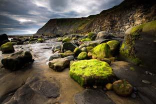
The port itself consists of a tiny derelict harbour with a few cobles beached nearby. It is probably easier to reach it from the sea and local residents do maintain fishing cobles in Port Mulgrave.
A few years ago, my brother lived in one of those cliff-top houses and kept a fishing coble in what he called Port, the local name for this village. Most of people living in that area always refer to the village as Port.
Given its full name of Port Mulgrave, it boasts surprisingly little published history.
Most of my older reference books omit it entirely, although Harry Mead’s “Inside the North York Moors” (1978) and Alfred J Brown’s “Fair North Riding” (1952) do give it space. Small references also appear in some travel guides to the Yorkshire coastline, one mentioning the footpath down to the shore.
It is a very difficult climb both up and down, and in wet weather it can be dirty and slippery.
Nonetheless, it does have its rewards. A walk along the shore – always with the state of the tide in mind – can be rewarding due to the variety of marine and coastal life, not to mention the likelihood of finding some raw jet.
That remarkable path down the cliff was once known as the miner’s track, having no steps and a very steep, rough surface. It was never a proper road or path.
On our visit, it was a hair-raising descent but the name “Miners’ Track” provides a clue to the purpose of Port Mulgrave. Another clue is evident when you reach the bottom.
Overlooking the remains of that miniature harbour is the mouth of a large tunnel which disappears deep into the cliff and is now barricaded to prevent entry. The harbour was constructed about 155 years ago so that ships could convey ironstone from Port Mulgrave for processing at Jarrow.
The ore was mined inland via shafts which were sunk down to the seams near Grinkle and the threemile long tunnel was built to transport the ore to the ships waiting in Port Mulgrave harbour.
A narrow gauge railway line linked Grinkle to the harbour where barges, towed by paddle steamers, would take the ore to Jarrow.
It was a busy and colossal operation, but typical of the enterprising hard-working businessmen of the period.
The Jarrow ironworks were owned by Sir Charles Palmer and it was he who built his country house at Grinkle. Known as Grinkle Park, it is now a hotel but few visitors will associate that fine building with the scant remains of a peaceful old harbour on the coast just a few miles away. A winter’s walk along part of the Cleveland Way between Runswick Bay and Staithes took us high above the beach with a chill wind encouraging us not to linger in spite of the dramatic views. To keep warm we had to move at a brisk pace with little time to stand, stare and admire, but as a winter outing, the trek was both rewarding and stimulating.
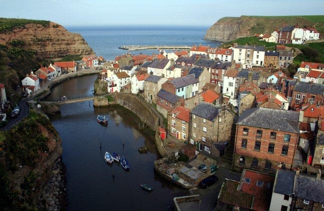
Staithes is fascinating and although it is very popular now, this wasn’t always the case.
A guidebook of the 1880s described it as highly picturesque and highly unsavoury. It was a noted herring station with smokehouses built into the cliffs for drying them.
Fish were also cured on the beach – after being soaked in brine and pickle, they were laid out to dry and it was this pungent atmosphere that upset that writer.
Nonetheless, our lunch in an almost deserted Staithes was a fitting end to our trip.


Comments: Our rules
We want our comments to be a lively and valuable part of our community - a place where readers can debate and engage with the most important local issues. The ability to comment on our stories is a privilege, not a right, however, and that privilege may be withdrawn if it is abused or misused.
Please report any comments that break our rules.
Read the rules here