
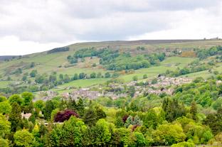
Pateley Bridge, situated on the banks of the River Nidd, is built on a steep hillside. It has only one important street, aptly named High Street, as it rises from the bridge across the Nidd.
The name Pateley derives from badger field, ‘pate’ being the badger and ‘ley’ the field. The bridge came later when the area became the property of Roger de Mowbray who is credited with having built a wooden bridge across the ford. The stone bridge followed in the 17th century.
The bridge was a meeting place for residents and visitors during feasts, fairs and market days. The most important day of the year for merriment was the great feast of September. It was known as the Netherdale Rant. Eating and drinking started at Pateley Bridge, then moved along the valley day after day until the partying satisfied even the most ardent drinker.
Pateley Bridge became prosperous in the days of lead which was mined on Greenhow Hill on the opposite side of the River Nidd.
Although there is evidence that the Roman’s may have been first to smelt lead on the steep hills around Pateley Bridge, it was the Cistercian monks from the abbeys of Fountains and Byland who really exploited the area.
They were given mineral rights from Roger de Mowbray in exchange for hunting rights over their land and became extremely rich.
After the dissolution of the monasteries, lead mining passed into private hands making the area around Pateley a place of some affluence.
Your route
Leave Pateley Bridge car park on the B6265 towards Grassington. Take the first turn right at the garage, signed to Ramsgill, Lofthouse and Middlesmoor, along a twisty road.
After about one mile, turn right over a packhorse bridge signed to Wath. Ride through the village and a little further along past some houses, then go uphill. As you almost reach the top, turn approaching a house, turn immediately left up a steep, narrow road.
Beware of drainage channels across the road here until you reach the top of the hill. They are very deep, you might have to dismount and walk over them.
It is quite a climb now, but eventually the road flattens and improves by losing its drainage channels, giving grand views all round. At the T-junction, turn left and look out for cattle grids as you enjoy the ride over open moorland. At the next T-junction, turn left, again signed to Laverton and Kirkby Malzeard to negotiate severe double bends and hills.
After a couple of miles on a straight road over Dallow Moor, turn right signed to Skelding and Grantley. This narrow road is long and straight, but beware of the approaching double bends.
Continue along, still following signs for Grantley on another long but undulating straight road ending in a T-junction.
Turn right now signed to Grantley and Risplith, passing through Grantley village with the Grantley Arms offering refreshment before continuing along following signs for Sawley and Risplith. Watch-out for double bends and eventually a steep descent.
At the main road, the B6265, go right signed to Pateley Bridge, then almost immediately left onto a narrow road signed to Sawley.
Not far to Sawley and the Sawley Arms, then to a T-junction to turn right signed to Ripley, Knaresborough and Harrogate.
Take care on this twisty narrow road and watch-out for a steep descent along the way, before looking for a right turn to Warsill and Brimham Rocks.
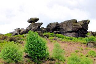
A twisty, hilly narrow road now but soon you will recognise the familiar shape of Brimham Rocks on the left. At the T-junction, turn left signed to Brimham Rocks and Summerbridge.
Take care on this narrow twisty road, but make sure you enjoy the views of the rocks all around you.
The car park is on the right. Pass the rocks, continuing along to a crossroad. Turn right here signed to Smelthouses and Pateley Bridge. Beware of very steep hills on this twisty road and eventually turn right at the T-junction signed to Pateley Bridge.
This road can be quite busy at times but it isn’t far before you start the descent into Pateley Bridge for some well-earned refreshments.
The facts
Distance – 22miles/35km.
Terrain – Very hilly but with rewarding views. Stop along the way to visit the unique Brimham Rocks formed into curious shapes on their prominent hill top position.
Best map – OS Landranger 99.
Start/grid ref – Pateley Bridge, grid ref: 159656.
Refreshments – Grantley Arms at Grantley, Sawley Arms at Sawley, Pateley Bridge.


Comments: Our rules
We want our comments to be a lively and valuable part of our community - a place where readers can debate and engage with the most important local issues. The ability to comment on our stories is a privilege, not a right, however, and that privilege may be withdrawn if it is abused or misused.
Please report any comments that break our rules.
Read the rules here