
In the year 1144 a monk, Peter de Quincy, from Normandy, arrived in Yorkshire where he had heard that the people who lived there were in great need of religious instruction!
He was granted a site near Askrigg in the Yorkshire Dales. He settled there with 12 other monks who made shelters from the local stone, but before they could build their monastery, they were attacked by the locals and their shelter destroyed.
Peter thought he would try his luck at Byland and he and his brothers lived there for a short time before setting off towards Askrigg again. They became disorientated and were found by the Earl of Richmond who was hunting in the area. This was a fortunate occurrence.
The Earl favoured the monks and gave them land at Jervaulx where they commenced to build their abbey in 1156. The monks soon prospered, and owned many acres of land close to the River Ure where they farmed sheep, and mined lead and coal.
The last Abbott of Jervaulx, Adam Sedbergh, was executed in 1537 for taking part in the Pilgrimage of Grace which was a protest against England’s break with Rome and the Dissolution of the Monasteries.
The Pilgrimage of Grace in Yorkshire was dealt with swiftly, a total of 216 lords and knights, half a dozen abbots, 38 monks and 16 parish priests were put to death at York. The abbey was stripped of its wealth and left as a ruin.
Jervaulx Abbey still stands today and is a glorious ruin. No restoration has taken place and the stone building lives in harmony with nature which has enhanced the beauty of this impressive, once very rich, abbey of Jervaulx.
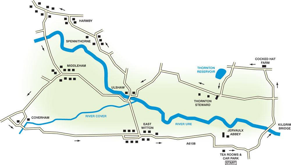
Your route
Leave the Jervaulx car park, not forgetting to put your pound in the honesty back at the exit, then turn right onto the road.
Soon the road veers sharply to the right, leave it to go straight ahead onto a narrow road following the sign for Bedale.
Watch out for sharp corners and loose surfaces on this road.
Enjoy the all-round views as you cycle nonchalantly along and soon you come to the infamous Kilgrim Bridge, where the devil took his revenge on the farmer’s dog. Cross with care, then at the crossroads, go straight ahead signed to Newton-le-Willows.
Rolling hills now until you reach the junction at Cocked Hat farm where you must turn left to continue climbing to the crossroads. Go left here at the brown Byway Loop cycle sign.
Good views again and soon you start to descend past Thornton Reservoir where the road narrows and still descends quite steeply to a sharp corner.
Turn right at the T-junction following the Byway sign, then soon go left once again signed Byway. Downhill now with lots of bends and fantastic dales scenery to look at – a dangerous combination.
Beware! T-junction ahead. Turn right here signed to Spennithorne and Harmby. Soon turn left signed to Spennithorne and Leyburn, pass the Old Horn Inn, then turn left signed to Harmby and Leyburn.
Cycle along through Harmby enjoying the grand views across Wensleydale to Middleham with its fine castle and beyond. Climb the steep hill through the village, the turn left signed to Leyburn, Richmond and Hawes.
Not far and you reach Leyburn. If you wish to explore Leyburn carry on straight ahead, then return to this point. If not, turn left signed to Middleham and Ripon. Steep downhill now, then over the fine bridge over the River Ure to cycle along to Middleham with its impressive castle.
Explore here if you wish, then bear right through the market place past the castle following signs for Coverham.
Uphill now to cross Middleham Low Moor with the horse gallops on the right and great views along Coverdale.
Eventually turn left following the sign for Coverham at the historic church, then wend your way through the village, over a bridge across the River Cover, then turn left signed to East Witton and Masham.
A very narrow, slippery, twisty road for almost three miles to the village of East Witton. Turn right here onto the main road to cycle along past the Blue Lion Inn and church and in two miles you reach the car park at Jervaulx Abbey ready for that cup of tea in the café.
Cycle ride facts
Distance – 20 miles/32km.
Terrain – Narrow, quiet roads.
Best Map – OS Landranger 99.
Start/Grid ref – Jevaulx Abbey Tea Room car park, honesty box at entrance/exit, grid ref: 176854.
Refreshments – At the start and along the way at the village pubs or visit Leyburn and Middleham for pubs and cafes.


Comments: Our rules
We want our comments to be a lively and valuable part of our community - a place where readers can debate and engage with the most important local issues. The ability to comment on our stories is a privilege, not a right, however, and that privilege may be withdrawn if it is abused or misused.
Please report any comments that break our rules.
Read the rules here