
MALTON, as we know it today, is a bustling market town renowned for good food, friendly old-fashioned shops and a rich heritage of trade in its markets.
Steeped in antiquity, the town has emerged from Roman occupation and the Medieval age through trade.
Probably one of the most significant points in Malton’s history was when it became an inland port doing a considerable trade by water.
Its waterway for the goods was via the Derwent, Ouse and Humber to the great port of Hull.
In the 18th century, sloops and other vessels shipped many tons of corn and other farm products between the two towns.
A shipbuilding trade for servicing the sloops and small vessels flourished at Malton as the importance of this inland port grew.
Malton was the head of a river navigation system and small boats from Scarborough were able to carry fish through the Humber, Ouse, Derwent route.
In 1767, it was suggested that a more efficient link be constructed by a system of canals between Scarborough and Malton which would have opened up links to York from where fish could be taken into the West Riding.
The route was envisaged to go via Brompton, Thornton-le-Dale, Pickering to Kirkbymoorside, then on to Malton with a possible link to Helmsley.
Twenty-four locks were planned for the route. Alas, all these great plans were rejected and the expansion and importance of Malton as an inland port came to nothing.
Malton’s river trade declined as trade routes overland developed and Malton became renowned as a great market for horses, cattle and agricultural products and implements –not to mention the great breweries.
But what if plans had gone ahead for a better navigation system of the rivers and building of canals? Would Malton now be not only a great inland port but, like Skipton, have river and canal trips as a tourist attraction?
Your route Leave Malton via Norton, then take the Scarborough Road through Norton. At the second roundabout, go right, following signs for Beverley.
At the next roundabout, bear left to join the Beverley road. Keep straight at all times and in about a mile is the B1248.
Keep straight ahead at all times and in about a mile, turn left signed to Settrington. This good road ascends and descends and you eventually reach a T-junction. Go left here signed to Settrington, Scagglethorpe and Rillington.
Just a short ride, then turn right signed to Settrington House and Lutton. A long steep hill now as you climb onto the wolds. Keep following the signs for Duggleby and West Lutton as you bear right onto a well-surfaced but narrow road.
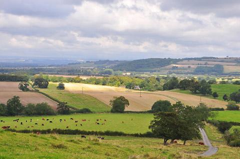
This road continues for about five miles with glorious views all the way. Keep straight ahead at all times and eventually you will arrive at a T-junction. Go right here signed to Kirbygrindalythe, Duggleby and Malton.
Cycle past Kirbygrindalythe, then in a mile, turn left downhill onto a narrow road signed as Yorkshire Wolds Cycle Route 166.
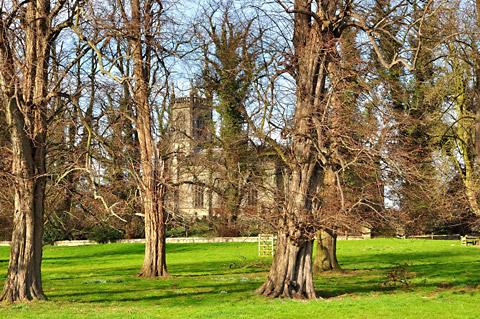
At the crossroads in Duggleby, go straight across signed to Wharram-le-Street, then keep left at the T-junction. At Wharram, go straight across at the crossroads onto a narrow road signed to Birdsall. If you wish to visit the church the entrance is from the main road down the hill a few paces.
Quite a good country road with views to enjoy across to the North York Moors on your right.
Soon look out for a steep descent with sharp, slippery corners. Keep straight ahead and slightly right at the crossroads – don’t take the Wharram Percy Farm road.
A regular amount of potholes and descents along here which get worse as you cycle along. If you go in autumn you will find the road littered with conkers and the open spiky shells of their birth.
Soon you reach the T-junction at Birdsall. Go right here signed to Langton and Malton and cycle through the village, then past the glorious church on the hill.
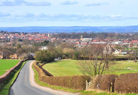
At the crossroads, go straight across signed to Norton and Malton. Soon you have a grand view across the two towns across to the moors as you descend into Norton. At the roundabout in Norton, go left, then right over the level crossing and the River Derwent to return to Malton.
The facts
Distance – 22miles/35km
Terrain – one steep ascent
Best map – OS Explorer 300
Start/grid ref – Malton, grid ref 785718
Refreshments – an abundance in Malton
Public toilets – near Market Place and adjacent to Wentworth Street car park


Comments: Our rules
We want our comments to be a lively and valuable part of our community - a place where readers can debate and engage with the most important local issues. The ability to comment on our stories is a privilege, not a right, however, and that privilege may be withdrawn if it is abused or misused.
Please report any comments that break our rules.
Read the rules here