
George Wilkinson heads to Newgate Bank and sets out across Rievaulx Moor, which he had never crossed before, but Google Maps suggested a path.
NEWGATE Bank has a good free car park, and a smashing viewpoint to one of the shapeliest parts of Bilsdale that is dominated by the sugarloaf-shaped Easterside Hill.
It’s a popular spot and people just pull in from the valley road that connects Helmsley to the south and Stokesley at the northern end.
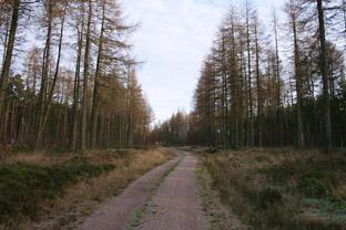
A gaggle of well-wrapped walkers set off, and we followed, through a band of conifers to garner the essence of the day with laid out before us the large flat of Rievaulx Moor, a moor now disconnected with Rievaulx Abbey some miles south.
We’d never crossed this moor before; a search on Google Maps showed a fair chance of a route, but there was the tang of uncertainty.
For a mile or so the route was a track, our trekking poles punching neat holes in the eighth of an inch of ice; the ground was hard and there seemed no defrost the whole day.
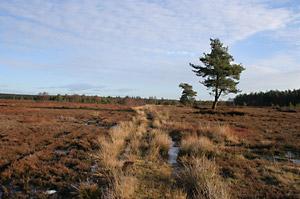
The fringe of woods came closer. We touched the edges and from the trees came a flurry of small birds, a mixed seasonal bag they were, for in the winter they give up competing for co-operating, as in the season of goodwill, but for survival. There were patches of a lovely russet grass and snipe zipped.
And we were doing all right but the moor is not, as it appeared, uniformly flat being sliced north to south by a number of stream gullies. Now a couple of these are quite steep-sided little things involving a bit of scrambling, but they were dry. However, and note, they might be otherwise, rushing rain water to the lowlands.
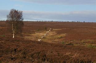
I hadn’t realised that this moor is laced with lines of grouse butts; you don’t see them from the popular track that we were to use for our return.
In places pine saplings were invading the heather from surrounding woods and in this mini invasion were the most exposed ant hills I’ve seen, a good example of the sort of ecology that might be if the heather weren’t burnt for the grouse.
In the distance some hunt hounds moved fast. We had slowed, taking careful steps when tracks gave out, keeping to short heather, meandering to find sheep paths.
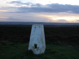
Eventually we reached the eastern edge of the moor, where it’s named Helmsley Moor, and here the thin back road, that runs south to that town, is a dead end up here with no traffic, and it took us to the steep escarpment that makes the northern boundary of the heather.
There are good views here, miles of them and a trig point at over a thousand foot. I was chatting to Max Goodwin, a North York Moors voluntary ranger, and in jest suggested the trig point needed a new coat of white paint, and with a laugh he said he’d see the Ordnance Survey got their brush out.
The rather grand arc of track took us under falling light, a buzzard cruised the vivid sky, and we were soon back. This is a useful spot if you’re worried about snow falling when you’re out because the road is mainly downhill to Helmsley and I believe the town’s Christmas tree came from today’s territory.
Directions
When in doubt look at the map. Check your position at each point. Keep straight on unless otherwise directed.
View a map of the Newgate Bank country walk>>
1. From car park, back towards entrance, 50 yards from main road left to gap by gate (fingerpost footpath) to main track through wood.
2. Leave wood (Rievaulx Moor info board), 50 yards, lesser track on right over moor.
3. At junction ignore track heading right/south towards woods.
4. At wood entrance with wooden gateposts, left to path/track on outside of wood, into and out of shallow valley through some saplings/trees then moor again.
5. Just before entrance to wood, left to lesser track, 100 yards, then right to narrow path to cross shallow valley. If you miss this path don’t worry – just skirt round, don’t enter top of larger valley with felled trees; through outlying pines, then pick up faint track that comes from a forest track in aforementioned larger felled valley.
6. Where wood cuts away sharply to the right cross moor, no path, where heather is shorter, 700 yards towards far end of wood.
7. Near end of wood find a way down and out of steep gully, and angle right/north-east keeping out of wood and outlying trees.
8. Cross gully, up to field corner, and take good track initially parallel and to the right of ditch.
9. Left to road.
10. At benches on brow, left to good track along top edge (footpath sign), pass trig point, back to car park.
Fact file
Distance: Six miles.
General location: North York Moors.
Start: Newgate Bank.
Right of way: Public paths and open access.
Dogs: Illegal.
Date walked: December 2011.
Road route: From Helmsley or Stokesley.
Car parking: Free car park.
Lavatories: At car park but closed in winter.
Refreshments: Helmsley.
Tourist and public transport information: Helmsley TIC 01439 770173.
Map: Drawn from OS Explorer OL26 North York Moors western.
Terrain: Moor.
Difficulty: Some scrambling.
Please observe the Country Code and park sensibly. While every effort is made to provide accurate information, walkers set out at their own risk.


Comments: Our rules
We want our comments to be a lively and valuable part of our community - a place where readers can debate and engage with the most important local issues. The ability to comment on our stories is a privilege, not a right, however, and that privilege may be withdrawn if it is abused or misused.
Please report any comments that break our rules.
Read the rules hereComments are closed on this article