
George Wilkinson visits Dalby Forest with a borrowed dog and finds a walk that’s perfect for canines and their human companions.
DALBY was an obvious choice as we had Merlot, a borrowed spaniel. He likes an element of freedom and he very much liked it the last time we brought him to the big forest.
After a bite to eat at the visitor centre restaurant (Merlot guzzled the leftovers), we drove the scenic Forest Drive, a “particularly fine stretch” wrote Lord Radnor, the chairman of the Forestry Commission when he welcomed visitors in the 1960s.
Three miles of the smooth Tarmac brought us to the Bridestones car park, where dog sniffed dog.
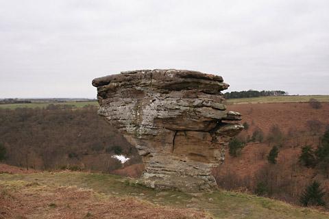
A path led into National Trust land, and up by a gully to the moor and there sat the first two Bridestones, dumpy and squat. Further along there’s one balanced on a narrow eroded neck of sandstone. They are sculpted by the weather and it was cold up here; icicles formed from rock drips, a few tiny particles of snow drifted around and Merlot broke ice to drink the peat-black water.
The moor here is nature reserve heather, not the grouse shoot variety.
To one side is the forest, but we stayed out and kept the landscape for a while. On a far pasture, a tractor pulled a muck-spreader; on another grazed a flock of sheep and beyond that lay the central mass of the moors. Then, for a mile or more, we took the fine high route along Crosscliff Brow, where the track was white with hardened snow.
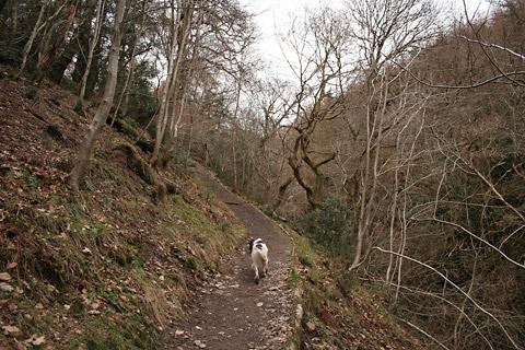
Finally, we turned into the forest, met a trundling Labrador and were out-sped by greyhounds.
It is fair to note that the Forestry Commission is very dog-friendly. This is rare in the modern Yorkshire countryside, national parks and all. The commission’s dog policy is of “minimum necessary restriction”, and though at the Dalby Centre they do suggest dogs should be within sight and sound, I should confess that Merlot’s sight is not his strong point, but his nose is and he always found us.
There didn’t seem to be much else for him to find. Wildlife was hunkered down, not a bird not a deer, and not a mountain bike.
Navigation, rather than nature, occupied us; with the tall trees all around and hardly a clue to the outside world bar a flash of view from Yondhead Rigg. One track junction looks like the next, the colour-coded posts here are for mountain bikes; a GPS is useful. But we noticed that things were warming up, the better side of zero for humans.
For Merlot the day certainly hotted up. At Staindale Lake, a “perfect picnic site”, the ducks sped across the water and the bulrushes were parted in the hope of a moorhen, but that was all, I promise.
Directions
When in doubt look at the map. Check your position at each point. Keep straight on unless otherwise directed.
1. From Bridestones car park (signed), path uphill, (National Trust sign), into wood.
2. In wood (info board) and fork right, uphill by gully.
3. On to moor, path for 100 yards, left to join path gently uphill.
4. At Bridestones, join path by and above the stones.
5. At end of these stones, EITHER LEFT across valley to see other stones and return to here OR fork right (waymark post), path for 50 yards then fork left (no sign), path through heather, gently drops for last few hundred yards by grass and birch trees.
6. Left (waymark post) to track by forest edge for half a mile.
7. Fieldgate (info board), 100 yards, right to track, 50 yards, fieldgate (waymark), track, one mile on Crosscliff Brow.
8. Main track on right at tall gas post and bench (mountain bike route markers – white arrow on red and green posts, and black opposite down Brow). Ignore track on left after 300 yards (various posts), gently downhill
9. At junction with new bench with badger sign of ‘Friends of Dalby Forest’ (white arrow on green and new as yet unsigned post), curve sharp left ignoring grass track on right.
10. At tracks/path junction stay on main track sharp right uphill, crest rise and pass picnic bench.
11. Left at track T-junction (white arrow on green) to grassy track downhill on valley side. Cross road to path by Staindale Lake, road to car park.
Fact file
Distance: Five miles General location: North York Moors Start: Dalby Forest – fee per car
Right of way: Public paths and open access Date walked: February 2013
Road route: From York via Thornton-le-Dale
Car parking: Bridestones car park, Dalby Forest
Lavatories: Dalby Visitor Centre and Bridestones car park Refreshments: Visitor centre
Tourist and public transport information: Dalby Visitor Centre 01751 460295
Map: Drawn from OS Explorer OL27 North York Moors eastern area
Terrain: Moor and slopes Difficulty: Moderate
• Please observe the Country Code and park sensibly. While every effort is made to provide accurate information, walkers set out at their own risk.


Comments: Our rules
We want our comments to be a lively and valuable part of our community - a place where readers can debate and engage with the most important local issues. The ability to comment on our stories is a privilege, not a right, however, and that privilege may be withdrawn if it is abused or misused.
Please report any comments that break our rules.
Read the rules hereComments are closed on this article